Kuzey Kıbrıs Şehirleri
TRNC NEIGHBORHOOD BOUNDARIES DATA
It is the vector format of TRNC administrative structure and borders data.
This data provides the neighborhoods listed by the TRNC Ministry of Internal Affairs in vector format.
You can obtain it in formats such as Esri shapefiles, SQL, GDB, KML, KMZ, JSON.
Kıbrıs Haritası

Kıbrıs adasının idari ve coğrafi haritası.
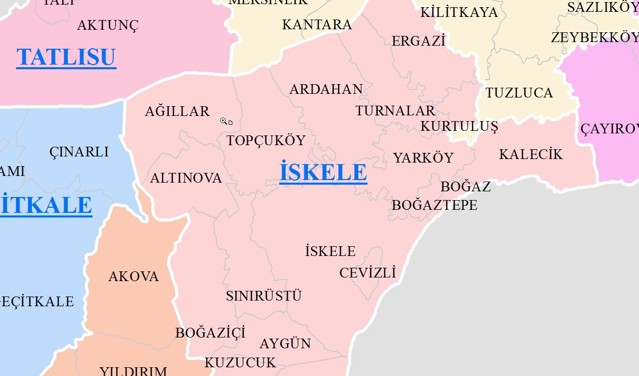
TRNC Neighborhood Data | Cyprus District and Neighborhood Borders
Accurate and high-quality village boundary data, compatible with the geographic reference system, includes street connections and development metrics; It is delivered in KML, KMZ, GeoJSON and SHP formats, ready for use in field and desktop applications.
Our colorful and high-quality district map solutions are equipped with location accuracy, street-avenue geometry sets and digital boundary layers; GeoJSON, SHP, KML and KMZ formats are supported for data transfer and are recorded with the geodatabase.
This digital district map; It provides geographic data accuracy, location-based development indicators, street and avenue geometries and neighborhood and village boundaries digitally; It can receive vector output in GeoJSON and SHP format, and is optimized for mapping engineers and data experts, compatible with KML/KMZ files.
Accurate geodata and vector maps for experts
SHP/KML/KMZ/GeoJSON delivery at neighborhood map, village boundary and street-street level. Get a quote for your colorful, high-quality and professional digital map needs.
Accurate and high-quality geographic data solutions
Neighborhood map, village boundary and street-based street network data; Delivered in GeoJSON, KML and SHP formats. Contact us for your expert project requests.
Professional neighborhood maps and geographic data packages
Colorful and high-quality digital map products prepared for experts. Click to purchase border and street data or have a map made in KML, KMZ, GeoJSON or SHP format.
TRNC DISTRICTS AND MUNICIPALITIES WITH MUKHTAR BORDERS
| DISTRICT | MUNICIPALITY |
|---|---|
| Lefkosia | NICOSIA |
| Lefkosia | GÖNYELİ |
| Lefkosia | DEĞİRMENLİK |
| Lefkosia | AKINCILAR |
| Lefkosia | ALAYKÖY |
| Girne | LAPTA |
| Girne | DİKMEN |
| Girne | ALSANCAK |
| Girne | ÇATALKÖY |
| Girne | GIRNE |
| Girne | ESENTEPE |
| Gazimagusa | GAZIMAGUSA |
| Gazimagusa | AKDOGAN |
| Gazimagusa | YENIBOGAZICI |
| Gazimagusa | TATLISU |
| Gazimagusa | PASAKOY |
| Gazimagusa | BEYARMUDU |
| Gazimagusa | GECITKALE |
| Gazimagusa | INONU |
| Gazimagusa | SERDARLI |
| Gazimagusa | VADILI |
| Guzelyurt | GUZELYURT |
| Guzelyurt | LEFKE |
| Pier | YENIERENKOY |
| Pier | ISKELE |
| Pier | MEHMETCIK |
| Pier | BUYUKKONUK |
| Pier | DIPKARPAZ |
KIBRIS
Cyprus Neighborhood Maps and Datasets
Village boundary datasets for experts provide geographic accuracy, street connectivity and development metrics; Data is delivered in GeoJSON, SHP, KML and KMZ formats and integrated with the geodatabase.
Digital maps created with neighborhood boundary data and street-street geometry sets are suitable for development analyses; Data is provided in GeoJSON, SHP, KML and KMZ formats and enables precise analysis thanks to the vector structure.
Expert solutions for street and avenue data
Color, vector and digital map packages; GeoJSON, KML and SHP supported. We provide services for professionals who want to have a map made or purchase geographical data.
Cyprus Neighborhood Boundaries — Nicosia, Kyrenia and All Districts
Vector data layers prepared for neighborhood development analyses present street and avenue references in digital format; Files support GeoJSON, SHP, KML and KMZ and provide centralized management with geodatabase integration.
Neighborhood map data presented in professional format combines geographic accuracy, location metadata and street-street references; Deliveries are made in GeoJSON, SHP, KML or KMZ format and are ready for vector workflow.
Colorful and high-quality neighborhood maps & geographic data
District map, village boundary and street map solutions in vector, KML/KMZ, GeoJSON and SHP formats prepared for experts — contact us to get professional, accurate and digital location data.
Digital map and geodatabase services
Street, street, neighborhood and village boundary data; Delivery in SHP, GeoJSON, KML/KMZ formats. Write to us for professional, accurate and expert-oriented geographic data solutions.
Digital map and geodatabase services
Street, street, neighborhood and village boundary data; Delivery in SHP, GeoJSON, KML/KMZ formats. Write to us for professional, accurate and expert-focused geographic data solutions.