Veriler
Azerbaycan İlleri
Mahalle - Sokak Verisi için Kesin Çözüm Sunuyoruz.
Sokak, Cadde ve Adres Verileri
Türkiye genelinde sokak ve cadde verilerini eksiksiz ve güncel olarak sunuyoruz. UAVT ve CSBM ile tam uyumlu veriler, şehir planlama, lojistik, analiz ve harita üretimi için idealdir.
Sokak & Cadde
- Türkiye’deki tüm sokakların tam listesi, eksiksiz ve düzenli güncelleme
- Türkiye’deki tüm sokak koordinatları
- Önemli caddeler ve perakende ticaret canlılığı indeksi (A, B, C, D sınıfı caddeler)
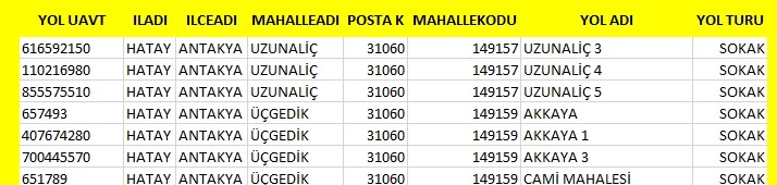
Adres Hiyerarşisi & UAVT
- İl, ilçe, köy, belediye, mahalle, sokak hiyerarşisi ve UAVT kodları
- Yerleşim niteliği, mahalle tipi
- Başlangıç ve bitiş kapı numaraları
- Daire ve işyeri sayıları
Sokak & Site İndeksleri
- Herhangi bir bölge için sokaklar ve sokak ismi bilinmeden verilen tarifler için özel liste veritabanı
- Sokak ve site indeksleri
Veri Güncelleme & İletişim
1 yıl içinde verileri tekrar alan kullanıcılar, bedelin %25’ini öder. Adres Harita Ltd., ürettiği her veriyi UAVT kodları ile uyumlu sağlar. Geçmiş ve güncel veriler ile çalışmalarınızda içiniz rahat olsun.
Geçmişe yönelik veriler de temin edilebilir.
Detaylı bilgi ve teklif için İletişime Geçin
Sokak verisi, Cadde verisi, Adres verisi, UAVT uyumlu, CSBM, Türkiye sokak listesi, Sokak koordinatları, Önemli caddeler, Perakende ticaret canlılığı, Sokak indeksleri.
Binalar ve Kapılar Haritası

Bina ve kapı numarası seviyesinde ayrıntılı adres haritası.
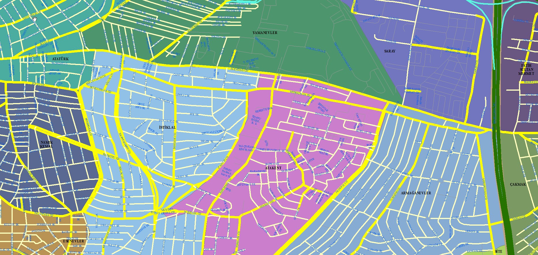
Mahalle ve Sokak Haritası

Mahalle ve sokak detaylı şehir haritası.
Street, Avenue and Address Data | Türkiye Address Map
Expert-specific geographic data set enables comprehensive analysis with district and neighborhood boundaries, street addressing and development layers; File formats are provided as GeoJSON, SHP, KML and KMZ, digital mapping is easy with vector data.
Vector street maps that comply with professional mapping engineering standards guarantee geographic data quality; location data is precise; File format options are provided as GeoJSON, SHP, KML and KMZ, in-geodatabase data management is provided.
This digital district map; It presents geographic data accuracy, location-based development indicators, street and avenue geometries and neighborhood and village boundaries digitally; It can receive vector output in GeoJSON and SHP format, and is optimized for mapping engineers and data experts, compatible with KML/KMZ files.
Professional location and street map service
We offer accurate digital maps, GeoJSON and SHP compatible geographic data, district and neighborhood boundaries and development analyses. The solution for experts who want to have maps made or buy data.
Vector maps and geodata packages
Street map, street network, neighborhood boundaries; professional data delivered with GeoJSON, KML/KMZ and SHP. Contact us to have a map made or to purchase data.
Detailed street and avenue data — accurate, reliable
Digital location files compatible with GeoJSON, KML and SHP; district map, neighbourhood boundary and village boundary data. Contact us for professional mapping and data purchasing. border-radius:12px; font-size:1.3rem; text-decoration:none;"> Contact us Map Examples
İl, İlçe, Mahalle Seçerek Adres Girişi

Çok seviyeli adres giriş harita arayüzü.
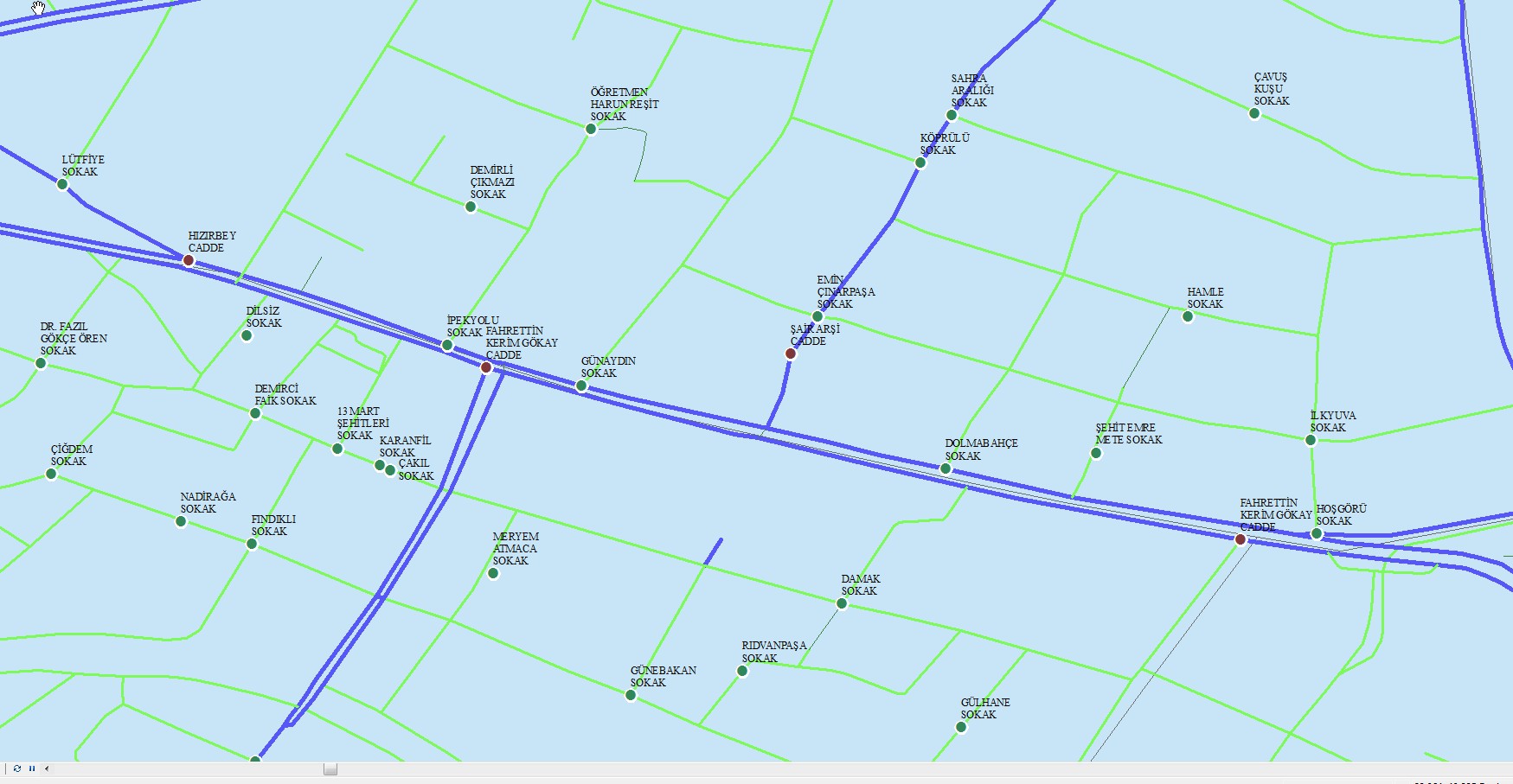
Önemli Sokak ve Noktalar Haritası

Önemli cadde ve noktaları gösteren harita.
Sayısal Olarak Sokaklar

Sayısallaştırılmış sokak verisi haritası.
Ticarette Öne Çıkan Cadde Haritası
Ticari yoğunluğun bulunduğu önemli cadde haritası.
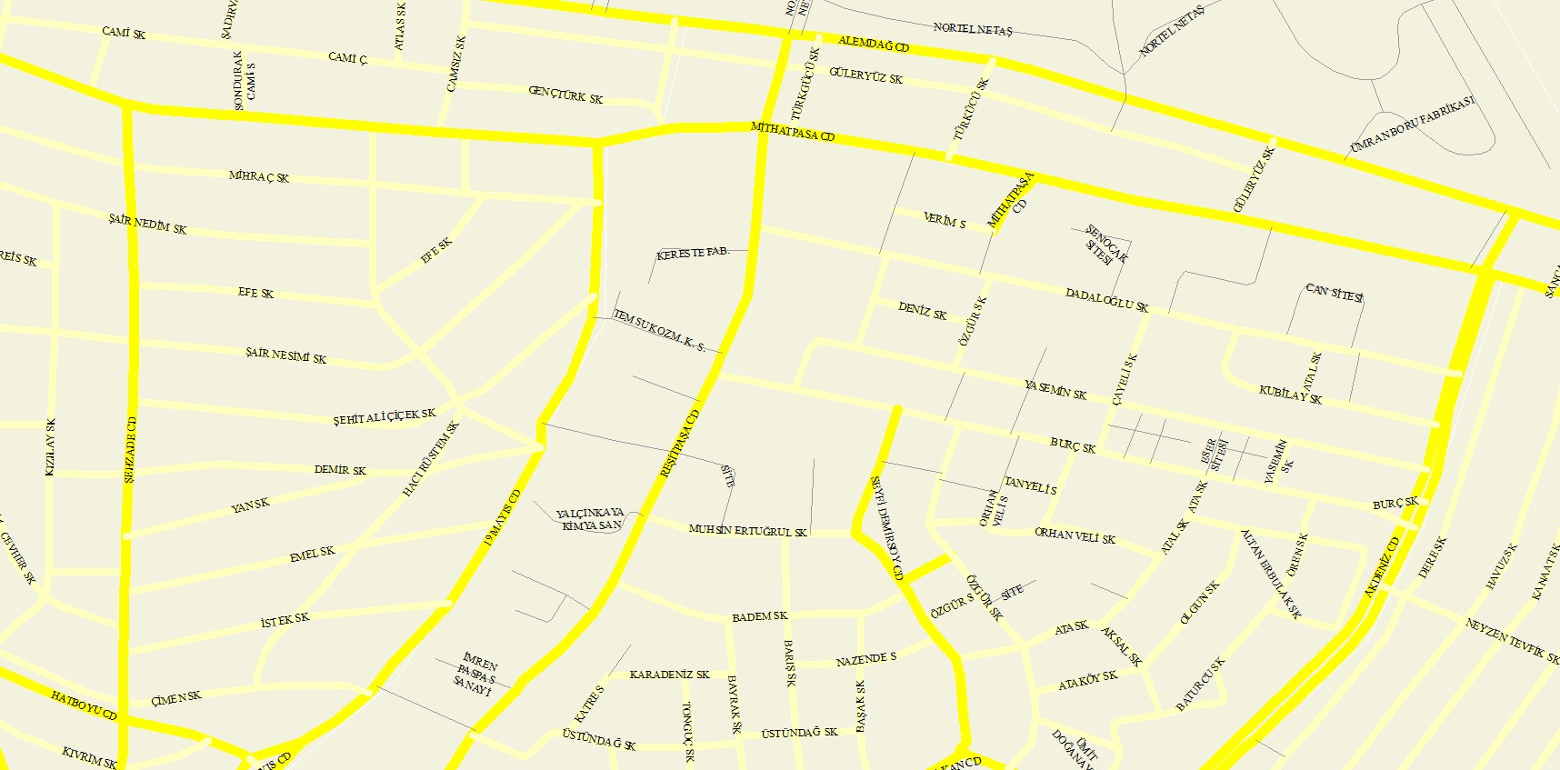
Yoğun Cadde Haritası

Yüksek yaya ve ticaret yoğunluklu caddeler haritası.
IMPORTANT STREETS DATABASE
Sokak Haritası

Sokak seviyesinde detaylı şehir haritası.
Sk En Haritası

SK EN kodlu bölge haritası.
Street Coordinate / Map / Neighborhood Relationship

Sokak, harita ve mahalle ilişkilerini gösteren yapı.
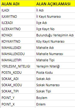
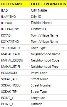
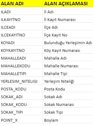
TABLE STRUCTURE
| AREA NAME | AREA DESCRIPTION |
|---|---|
| ILADI | Province Name |
| ILKAYITNO | Province Registration Number |
| ILCEADI | District Name |
| ILCEKAYITNO | District Registration Number |
| KOYADI | Located Settlement Name |
| KOYKAYITNO | Village Registration Number |
| NEIGHBORHOODNAME | Neighborhood Name |
| NEIGHBORHOODCODE | Neighborhood Number |
| NEIGHBORHOODTYPE | Neighborhood Type |
| LOCATION_NATURE | Settlement Nature |
| ZIP_CODE | ZIP Code |
| STREET_NAME | Street Name |
| STREET_CODE | Street Number |
| STREET_TYPE | Street Type |
| POINT_X | Longitude< |
| POINT_Y | Latitude |
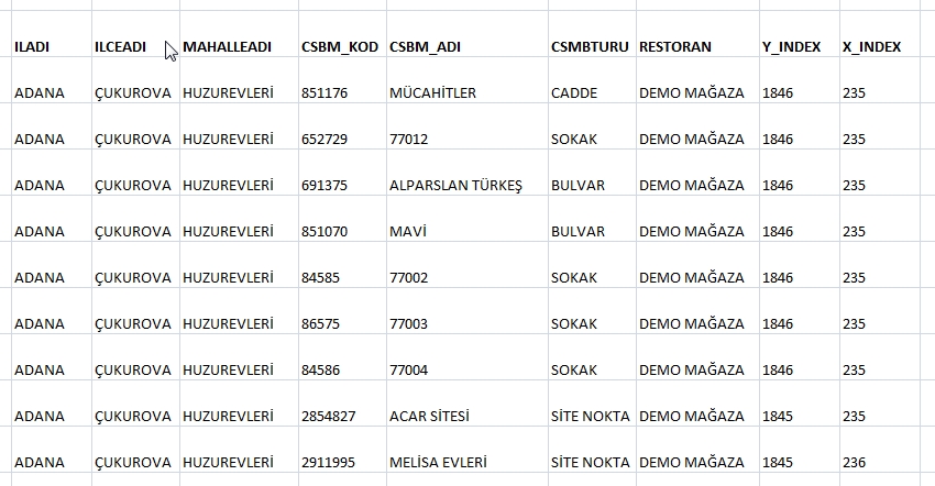
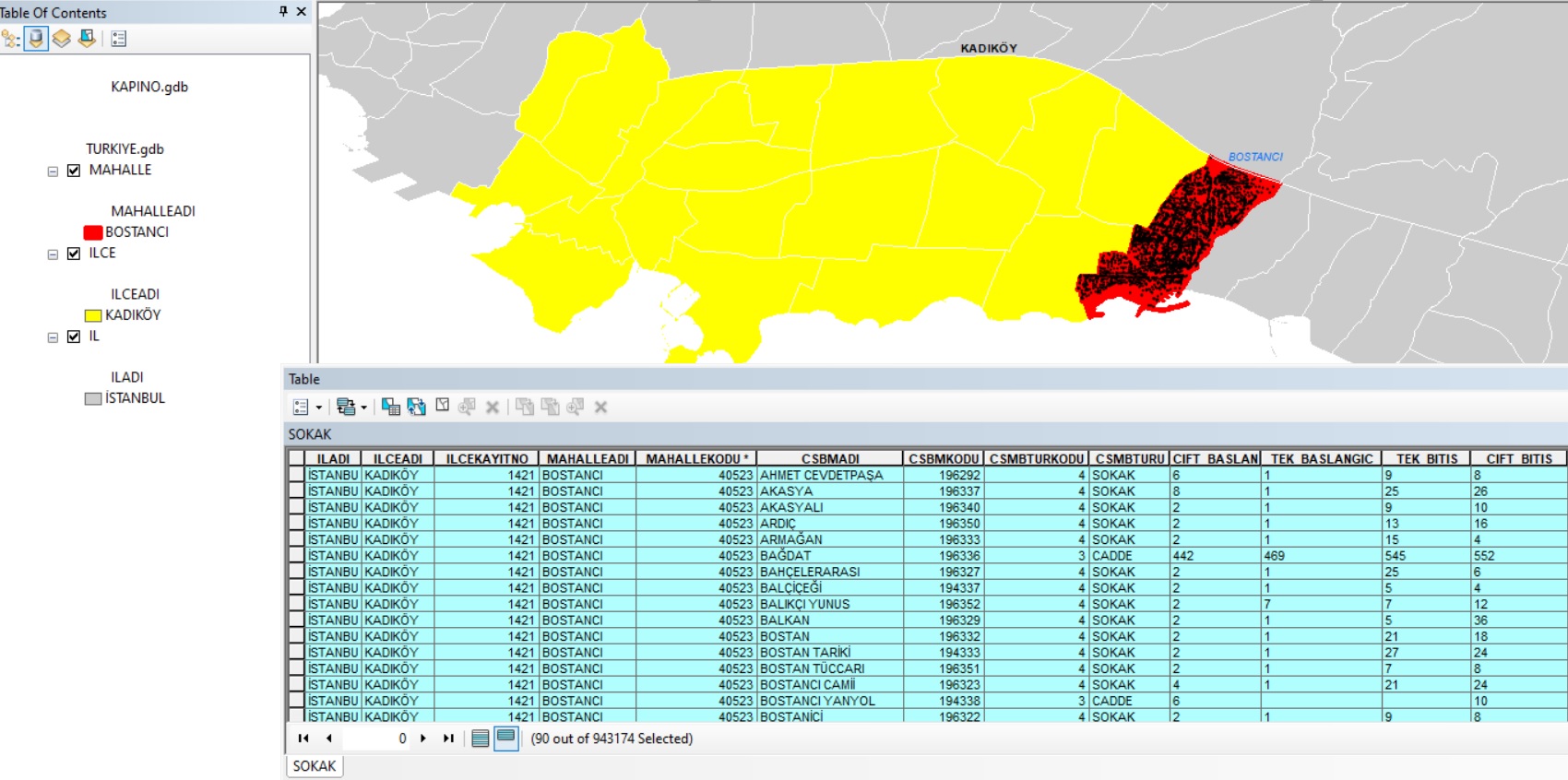
CSBM SOKAK TABLOSU
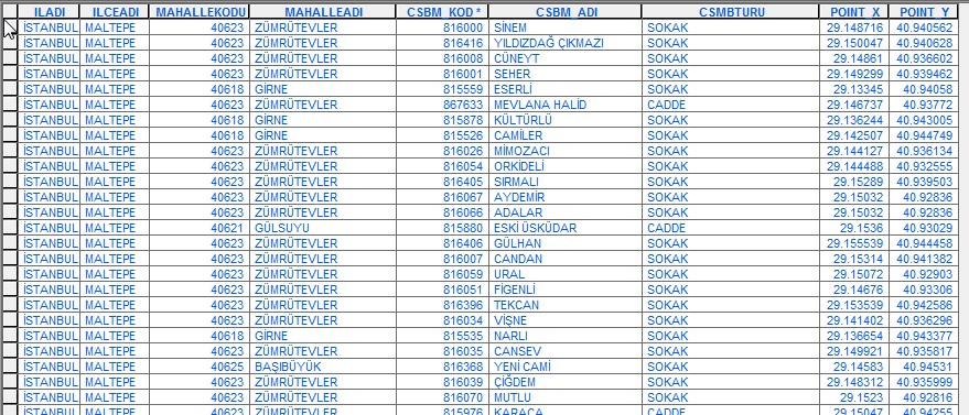
CSBM STREET TABLE

SOKAK
SK EN
STREET COORDINATE
STREET MAP
STREET NEIGHBORHOOD RELATIONSHIP
SOKAK INDEKS
İL İLCE MAHALLE SOKAK
SECEREK ADRES GİRİS
İLCE MAHALLE SOKAK